
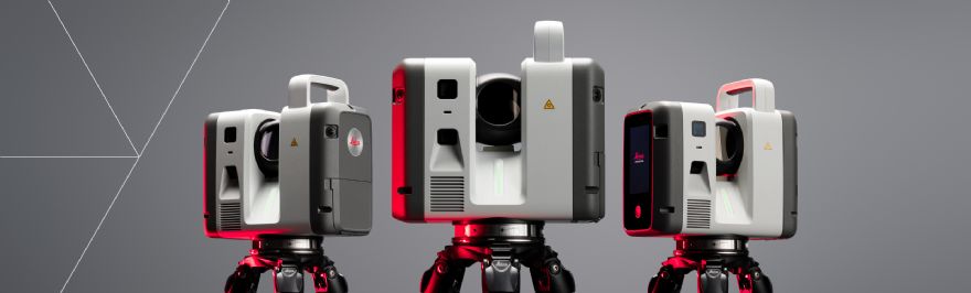
 Leica Geosystems, part of Hexagon, has launched the all-new Leica RTC series of terrestrial laser scanners: the Leica RTC300, 500, and 700. Built on Leica Geosystems’ decades of leadership in terrestrial laser scanning, the new series delivers substantial improvements in scanning speed, accuracy, and range, while introducing real-time workflow connectivity that keeps field and office teams aligned from first scan to final deliverable.
The new RTC series combines the speed, capability and versatility of the Leica RTC360 with the robustness and superior accuracy of the ScanStation P-Series, enabling specialised workflows across surveying, industrial plants, public safety, and infrastructure. It includes three performance tiers based on the same platform: As projects grow in size and demand, users can upgrade to a higher performance tier without replacing their system.
As project schedules compress and data volumes grow, geospatial teams are expected to deliver reliable, decision-ready information while work is still in progress. With the new RTC series, scanning, registration, and data sharing become one continuous process: 3D data moves between field, cloud and office. Livelink, a new capability in Leica Cyclone FIELD 360, streams scan data to Hexagon GeoCloud as it is captured.
Multiple scanners can feed into one shared project in real time. Teams can reduce rework by confirming they have covered the entire site before the field crew leaves – and start producing deliverables even before scanning is finished.
Tanja Birner, president at Hexagon’s scanning and mapping division, said: “The RTC series reflects where reality capture is headed: faster data capture, better connected teams, and a platform built to scale. It gives customers a more powerful way to work today and the confidence that their investment scales with them.”


Leave a comment